
Area: | Arosa |
Base: | 1750m |
Summit: | 2650m |
Skiable vertical: | 900m |
Lifts: | 11 (4 draglifts) |
Total lift vert: | 3750m |
Slope orientation: | East-facing |
 |
For a zoomable, scrollable map of the areas, see this online map using Openstreetmap or Opencyclemap.
By public transport, Arosa is at the end of a very scenic (but slow) train line from Chur. The Arosa train leaves from a separate platform outside the front of Chur station (labelled Bahnhofplatz rather than a platform number), and goes through the streets of Chur before following the valley upwards (the best valley views are on the right). The station in Arosa is almost right next to the lifts, making the transfers quite painless. As always, it's worth finding out the return train times before starting your last descent, as the trains back to Chur are roughly every hour. Arosa is part of the SBB "Snow and Rail" ticket scheme, but (like Lenzerheide), they insist on a CHF 5 deposit for their lift ticket. You can get your money back from the rail station on the way back.
By car, again you need to come via Chur, and follow the valley road up. This road is extremely twisty and takes a good 45 minutes to get up the valley from Chur, with some driving nerve required. That makes the drive from Zürich just under 2 hours in total, a good half hour quicker than the train. When you get there, a day pass is currently CHF 55, plus CHF 5 card deposit.
From Zurich, you need to take the train to Chur, which connects well with the train to Arosa. Cost of the snow and rail ticket is CHF 73, plus the mandatory CHF 5 deposit when you get there. It takes around 2h30 to get there, and around 2h50 to get back.
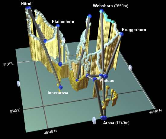 |
The resort has a fair selection of lifts of all types, serving mostly blue runs and easy reds. However, many of the runs are quite variable, with some fairly steep sections interspersed between flatter bits. Most of the runs lie between around 2000m and 2650m, although at the time of writing, the runs down to the base at 1740m are still open, with only a few brown patches.
There is a large amount of off-piste, between the runs in all areas. There's also a so-called "Free Ride Mountain" area, with lots of unpisted terrain, the only snag being the awkward lift connections from the Arlenwald area to get back up. There's a fun park just below the middle cable car station.
For the runs down to the base at the end of the day, it's good to work your way over to the cable car side, for the blue run down to the base station. Otherwise you can take advantage of the free buses around Arosa to get back from the other base stations.
Overall, Arosa gives a large area to explore, although many of the runs are quite similar to each other - you could easily just stick with a couple of lifts and get the same variety of runs (with less traversing). When we were there, the runs over towards the Hörnli side were somewhat wetter lower down than on the Weisshorn side.
Most of the slopes are very open, so navigation is not too much of a problem, although as always it would benefit from named runs and more signposting. Even the lifts here aren't named, except on the map. Take note of the last cable car time up to Weisshorn, this is currently 4:30pm.
There are a few traps for the unwary, first of all the plateau by the middle cable car station has a cluster of lift stations, but you could well find yourself walking from one to the other. Other sticking points include getting across to the bottom of the Hörnli lifts, and to the Carmenna lift. These are fine with speed, but slower riders may end up walking.
19 February 2006 - Lots of snow around but due to the high stormy winds, many of the lifts were closed for large parts of the day - at one point everything above the plateau was closed. So of course all the lift queues were pretty brutal as a result. Snow on the whole is very good, but being blown away on the tops.
No prizes for guessing arosa.ch, the slope map is available either as a plain picture or under 'karte' as an all-singing, all-dancing gadget (Flash required). Snow'n'Rail details are at railaway.ch. For snow conditions see snow-forecast.com.