
Hike time: | 3 hours |
Start: | Zugerberg Seilbahn |
Finish: | Zugerberg Seilbahn |
Season: | Winter |
Profile: | between 920m and 1040m |
Rating: | easy and medium length, with possible shortcuts |
The Zugerberg is the local mountain of the town of Zug, rising fairly dramatically from the low surroundings. The broad summit makes an ideal walking area, with views over the town and lake below, especially as it is so easily reached with the steep railway. Further South is the higher peak of the Wildspitz, but this Winter walk leads around in a relatively flat loop.
In the Summer, there are three signposted walking trails - 'rabbit', 'fox' and 'deer', varying in length from 1.5 hours to around 3.5 hours. In the Winter, special pink 'Winterwanderweg' signs lead round numbered trails, following roughly the same routes as the Summer trails but occasionally detouring on deserted roads rather than narrow footpaths.
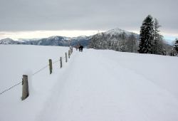 The path leading towards Rigi 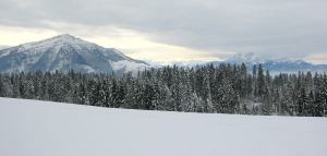 Looking across to Rigi and Pilatus 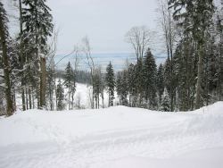 The view out across the plain below |
From Zug, take the number 11 bus to Schönegg, and then the cable train up to Zugerberg. The walk starts from the upper station.
From Zurich, many trains and S-bahns connect to Zug, and the bus stop for the number 11 is on the main road just a short distance from the main station. A day return ticket to Zugerberg (including train, bus and cable train) costs CHF 19 with halbtax.
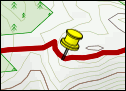
For a zoomable, scrollable map of this hike, see this online map using Openstreetmap or Opencyclemap.
You can also download this kmz file zugerberg.kmz to open it in programs like Google Earth or GpsPrune and then transfer the track to your GPS.
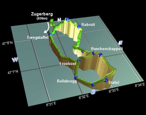
Zugerberg - Ewegstaffel - Früebüel - Balisbrugg - Stafel - Buschenchappeli - Rabrüti - Zugerberg
 |
The Winter walks on the Zugerberg are numbered 1, 2, 3 and 4, and are clearly marked with bright pink signposts. Most recommended, and described here, is a combination of numbers 2 and 3, although number 2 on its own makes a good, shorter alternative.
From the upper cable train station at Zugerberg, follow the path uphill to the left to a major path junction, where all the Winter trails are signposted the same way. Turn right here, following the signposts, to emerge from the buildings on a quiet trail. Rigi and Pilatus should appear fleetingly between the trees on your right. The path is relatively flat as far as Altenboden, reached after around 25 minutes.
The path now begins to climb, leaving the cross-country skiers behind, and after around 15 minutes reaches Ewegstaffel. Here, route number 1 departs to the left, but note that around half-way to Rabrüti this path becomes unprepared snow, making it hard work. The Sculpturenweg makes an easier, if less scenic, alternative route back from here.
Continuing on our route number 2, the path descends gently giving splendid views of nearby Rigi, to arrive at a small cluster of farm buildings at Früebüel after around half an hour. Here, the path splits again, with route 2 turning left to take the shorter, direct route to Buschenchappeli, and route 3 turning right for the longer route round. Unfortunately, the signposts for these routes only go in one direction, and those for route 3 are marked in the opposite (clockwise) direction from the others. So for the Southernmost loop we will have to go against the pink signposts.
At Früebüel, turn right down the narrow lane, signposted for Balisbrugg and Stafel. At Balisbrugg, after around 10 minutes, turn left signposted Stafel, and follow the straight road to Chatzenbergegg after another 10. Here, the road starts to climb more steeply, giving plenty of excuse to stop and look back at the views.
Shortly you reach Stafel, and continue to climb in the direction of Pfaffenboden. A signpost directs you leftwards, still towards Pfaffenboden, and up to the highest point in the walk, before easing along to the restaurant at Pfaffenboden after around 20 minutes. Another 5 minutes then brings you to the tiny chapel at Buschenchappeli, where the walks numbered 2 and 3 once again meet.
From Buschenchappeli, the pink signs direct us on Northwards to Schwändi and uphill through the thick woods to reach Rabrüti after around 40 minutes. The views to the West are particularly good from this high portion of the route.
From Rabrüti, the footpath follows the so-called "Sculpturenweg", along which there are many carved animals
lurking by the side of the trail. Some of these can be especially difficult to spot after a fresh snowfall. After
passing an "Aussichtspunkt" (viewpoint and picnic area), the path descends down to meet the outbound route, from
which you can retrace your steps to the Zugerberg station, after around 45 minutes from Rabrüti.
The following are the coordinates for waypoints along this route, obtained from GPS. They can be used either in another GPS, or along with a map, to provide additional references if necessary.
                           Latitude       Longitude    Altitude(m)
        Schönegg          N 47°09'04.9    E008°31'15.3     555
        Zugerberg         N 47°08'38.0    E008°31'58.9     925
        Altenboden        N 47°08'03.5    E008°31'41.3     946
        Ewegstaffe1       N 47°07'43.2    E008°31'35.8     990
        Früebüel          N 47°06'46.0    E008°32'09.9     980
        Balisbrugg        N 47°06'29.8    E008°31'58.6     939
        Chatzenbergegg    N 47°06'11.7    E008°32'21.4     952
        Stafel            N 47°06'06.4    E008°32'39.3     988
        Pfaffenboden      N 47°06'37.1    E008°32'45.7    1026
        Buschenchappeli   N 47°06'43.4    E008°32'36.3    1022
        Schwändi          N 47°07'00.1    E008°32'26.4     986
        Rabrüti           N 47°07'40.3    E008°32'36.3    1020
        Aussichtspunkt    N 47°08'01.6    E008°32'21.2    1017
zug-tourismus.ch has general tourism information about the area, including descriptions of the Summer walking paths labelled rabbit, fox and deer. Also gruxa.ch has more descriptions of walks on the Zugerberg, and of the Sculpturenweg.